A Tale of Two Cities
by Chuck Banas

Madison, Wisconsin hosts the annual Congress for the New Urbanism this week. Not coincidentally, there is a connection between Buffalo and Madison: The CNU will be in Buffalo in 2014, and my coverage this week affords an opportunity to examine this event and the issues as they apply to the Buffalo area. I’ll also be looking at what we in Buffalo can learn from the City of Madison, regarded as one of the most progressive cities when it comes to urban planning—and the great quality-of-life that has resulted.
Let’s start with a specific issue: street design. The Congress didn’t officially start until Wednesday, so I used Tuesday to get to know a bit of downtown Madison and critique the design of the streets and public spaces. A design subtlety that is lost on most non-planners is that sidewalks are a necessary element for safe street design but insufficient in themselves. If pedestrians are being endangered, the design speed of the road is usually the culprit. Many, if not most, roads in this country are intentionally designed for much higher speeds than the posted limit. A 30 miles per hour speed-limit sign on a road designed for 50 or 60 miles per hour is a futile—and sometimes fatal—exercise in wishful thinking.
Here are the sobering facts: at 30 miles per hour, vehicle-pedestrian accidents are fatal in about five percent of cases; at 40 miles per hour, fatalities are 90 percent. This is not to mention injuries, which can be devastating in their own right: non-incapacitating injuries are significantly less likely and less severe at slower speeds.
Therefore, the actual, effective solution involves “traffic-calming” the roadway so that drivers naturally move at slower, safer speeds. There are many methods to accomplish this, used in various combinations according to the specific situation. These include: fewer and/or narrower lanes, planting orderly rows of roadside trees, allowing curbside parking, using brick or other types of pavers for the road surface, curb bulb-outs, employing roundabouts instead of signalized intersections, smaller corner radii, etc.
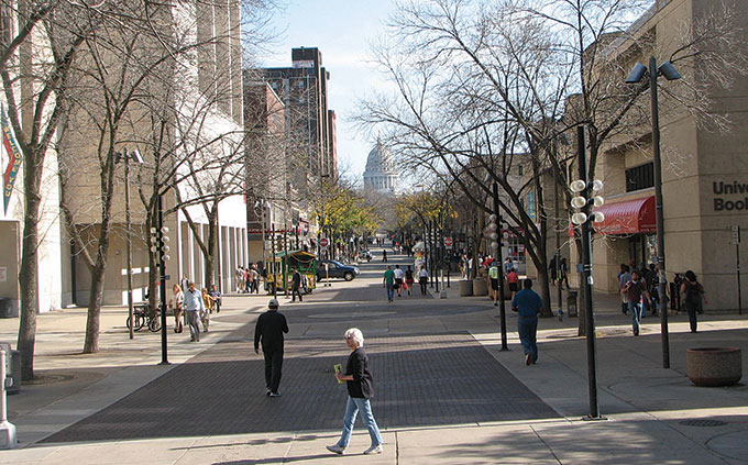
State Street in Madison employs virtually all of the basic traffic-calming devices, including a narrow roadway, wide sidewalks, and orderly rows of curbside trees. This results in a street that easily accommodates all modes of transportation while being a pedestrian destination—it’s simply a pleasant place to be.
Done properly, traffic throughput is still maintained, with less stop-and-go frustration for drivers, and much greater safety and civility for all users of the roadway, including pedestrians and bicyclists. For the vast majority of surface roads, there is simply no reason to design for a speed limit over 30 miles per hour. Doing so seems downright careless and irresponsible, which is the unfortunate norm for most highway departments.
This isn’t to say that traffic engineers are malicious—they’re just following a prescribed set of rules. The engineering standards that govern most roadway design were written in the mid-20th century, in the midst of a obsession with the automobile and the high-speed expressway. Higher design speeds were considered safer for cars and drivers. This myopic goal ignored any other users, as well as the physical context of the road itself. That the road might be part of a town or city neighborhood hardly entered into the equation. Under these standards, still in effect today, roads are too-often treated identically to expressways, designed only for the high-speed convenience and safety of cars. What happens beyond the curb or shoulder doesn’t matter.
Buffalo’s Elmwood Avenue, the urbanistic equivalent of Madison’s State Street, employs many of the same traffic-calming methods, but sidewalks are often too narrow, driving lanes too wide, and street trees are often missing or poorly maintained.
The good news is that the rules are changing. The old standards, embodied mainly by the AASHTO highway design manuals, have been superseded by new tools and standards, most recently (and importantly) the ITE design manual Designing Walkable Urban Thoroughfares: A Context Sensitive Approach, adopted in 2010. Traffic engineers and citizens alike now have a sophisticated set of official standards with which to design roads that serve all users and all contexts.
Incidentally, on May 24, Transportation for America released a comprehensive report on pedestrian deaths. Dangerous by Design studies 47,000 pedestrian fatalities in the US from 2000-2009, mapping them on an interactive web page. Enter any location, and find out details on fatalities, thoroughfare type, etc. Check out pedestrian fatalities in your neighborhood; you may learn something about street design and safety in the place you live.
blog comments powered by Disqus|
Issue Navigation> Issue Index > v10n22 (Summer Guide, week of Thursday, June 2) > Week in Review > A Tale of Two Cities This Week's Issue • Artvoice Daily • Artvoice TV • Events Calendar • Classifieds |


 Current Issue